

Every successful construction project begins with a clear understanding of what lies beneath the surface. While architectural plans and structural designs receive significant attention, the condition of the ground itself plays an equally important role. This is where Geophysical Surveys become valuable. These investigations help engineers gather information about subsurface conditions without extensive excavation, making them an important first step for many infrastructure and construction projects across Chennai.
As Chennai continues to expand with residential developments, commercial complexes, industrial facilities, highways, metro projects, and public infrastructure, builders increasingly rely on scientific site investigations to reduce uncertainty before construction begins. Ground conditions can vary significantly even within a short distance, making early assessment essential for project planning.
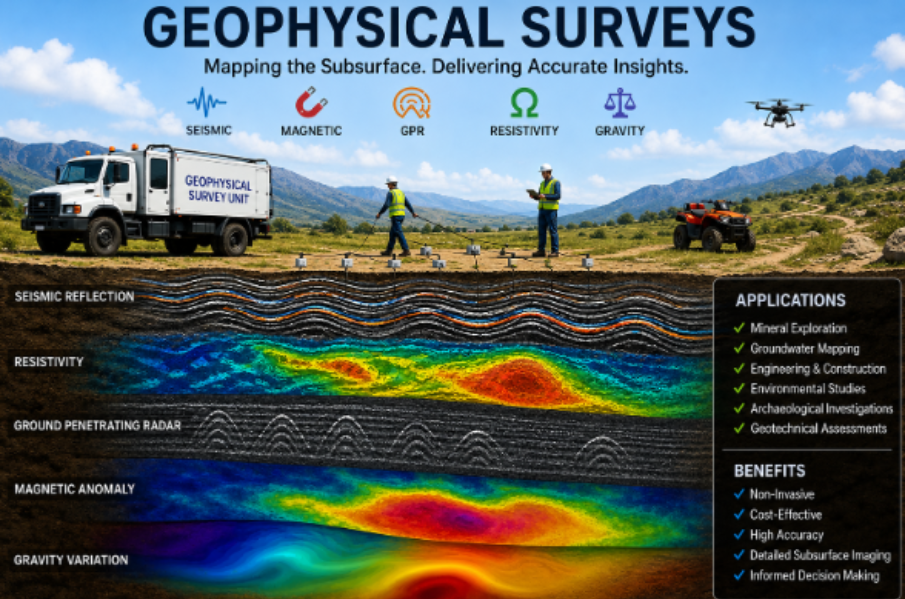
Unlike traditional exploratory methods that require multiple boreholes, geophysical surveys use scientific instruments to study underground features through physical properties such as seismic wave velocity, electrical resistivity, and density variations. The collected information helps engineers understand soil layers, weathered rock, groundwater conditions, cavities, and geological discontinuities.
Some of the common applications include:
- Site suitability studies
- Foundation planning
- Highway and railway projects
- Dam and bridge investigations
- Industrial construction
- Urban infrastructure development
- Environmental assessments
- Utility corridor planning
One of the biggest advantages of geophysical investigations is their ability to cover large areas efficiently. Instead of relying solely on isolated borehole locations, engineers obtain continuous subsurface information, leading to better-informed engineering decisions.
For projects in coastal regions like Chennai, understanding groundwater levels and soil variability is particularly important. Soft marine deposits, reclaimed land, and varying geological formations require detailed investigation before selecting foundation systems.
A typical geophysical survey may involve techniques such as seismic methods, electrical resistivity surveys, ground vibration measurements, or other specialized testing depending on project requirements. These methods are selected based on the site's geology and the engineering objectives of the project.
The benefits of conducting geophysical surveys before construction include:
- Reduced construction risks
- Improved foundation design accuracy
- Better estimation of excavation requirements
- Early identification of geological anomalies
- Lower chances of unexpected delays
- Enhanced project safety
- More efficient budgeting
For large infrastructure projects, geophysical investigations also support compliance with engineering standards and project specifications issued by government agencies and consultants.
Another important advantage is the reduction of unnecessary drilling. While boreholes remain an essential part of geotechnical investigations, combining them with geophysical data often provides a more comprehensive understanding of subsurface conditions while optimizing investigation costs.
Experienced service providers such as NEXGEN INTEGRATED GEOSOLUTIONS PVT LTD integrate geophysical studies with engineering interpretation to support consultants, EPC contractors, infrastructure developers, and industrial clients. By combining field investigations with technical expertise, the company helps project teams obtain reliable data for informed engineering decisions.
Selecting the right investigation approach depends on several factors, including project size, proposed structure, local geology, groundwater conditions, and engineering objectives. A well-planned investigation ensures that design assumptions are based on actual site conditions rather than estimates.
For developers and engineers working across Chennai and other parts of Tamil Nadu, investing in detailed geophysical surveys before construction is a practical step toward minimizing uncertainty, improving structural safety, and supporting long-term project performance. Reliable subsurface information enables better planning, reduces avoidable risks, and contributes to efficient execution throughout the construction lifecycle.